Big drop in temperatures heads to Charlotte area Wednesday. How low will it get?
A weather whiplash is hitting the Charlotte area this week, as daily highs tumble from the 90s to the 60s.
Read more Suspect fatally shot by CMPD officer was a 47-year-old man. His name is released
Monday saw a high of 92 degrees.
Wednesday’s high will be 66 in Charlotte, 63 in Shelby and 62 in Greensboro, the National Weather Service says.
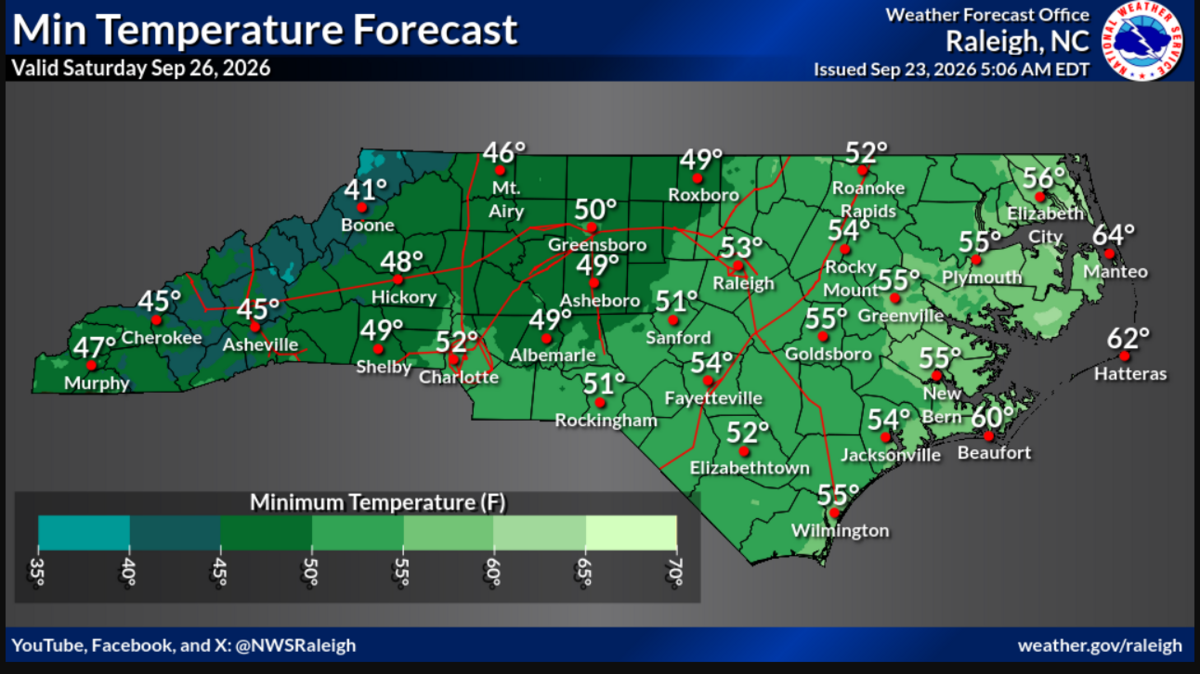
Nightly lows in the region will be downright chilly starting Thursday, including 51 degrees forecast for Charlotte, and 49 degrees expected in Shelby and Albemarle.
Tuesday was the first day of fall, so the cooler temperatures are perfectly timed, the NWS says.
A warming trend is ahead, but not until Monday when a high of 80 degrees is forecast. Until then, the region can expect five days with highs in the 60s and 70s, the National Weather Service says.
The pleasant temperatures are linked to a cold front that is also bringing thunderstorms, strong winds and excessive rain.
Read more Charlotte Hornets complete trade with Atlanta Hawks to acquire Buddy Hield
Parts of north Charlotte recorded nearly an inch of rain in the past 24 hours, the U.S. Geological Survey says. The highest total was 1.45 inches at Robert L. Smith Park in northwest Charlotte.
Statesville recorded nearly 3 inches of rain in the past 24 hours, the USGS said.
“Warmer temps trend through the middle of next week. However, these look to be closer to normal and not the oppressive heat from the summer,” the National Weather Service says.
“Also, with the northerly winds, drier air remains locked in through at least Tuesday, meaning humidity should be lower.”
Read more 2 NC destinations rank among the nation’s best for millennials. Here’s why