‘Prepare, don’t panic.’ Isaias could bring NC mountain mudslides, 8 inches of rain
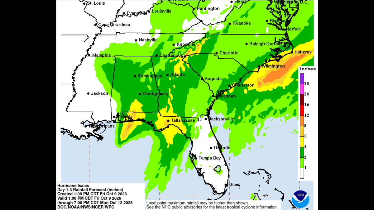
Hurricane Isaias could dump up to 8 inches of rain on the North Carolina mountains, producing life-threatening flash flooding, mudslides and “scattered to numerous power outages,” a National Weather Service meteorologist said Friday.
Read more 11-year-old Brexton Busch caps emotional tribute to his father Kyle in Charlotte
And tornadoes spawned by the hurricane threaten the Charlotte-Rock Hill area on Sunday, before the unsettled weather is forecast to leave the region around 2 p.m., Chaney said.
Charlotte flights and weekend events also were canceled Friday as Isaias became a major hurricane in the Gulf and N.C. Gov. Josh Stein urged residents statewide “to prepare, don’t panic.”
Swift-water and search-and-rescue teams were being repositioned across the state Friday “to quickly respond to any community that experiences impacts,” N.C. Emergency Management Director Will Ray said.
State highway officials are “closely monitoring conditions and will take action to keep roads safe and accessible once it is safe for crews to do so,” N.C. Secretary of Transportation Daniel Johnson said.
Stein urged everyone to sign up for local emergency alerts, have an emergency kit in case of a power outage and never drive through flooded roads.
“Take care of your loved ones, and check on your neighbors, too,” the governor said in a statement Friday.
Isaias grew into a category 3 hurricane around 8 a.m. Friday.
At 11 p.m. Friday, the storm was about 45 miles northeast of Pensacola, Fla., according to a National Hurricane Center bulletin.
The powerful storm packed 90-mph winds, down from 110 mph three hours earlier, with the threat of damaging winds and flash flooding spreading inland, National Hurricane Center meteorologists said.
Isaias is expected to dump 2 to 3 inches of rain Saturday into Sunday in the Charlotte region and Upstate South Carolina, and 3-4 inches or more in the mountains, according to the National Weather Service in Greer, S.C.
The heaviest rains are expected 8 p.m. Saturday to 2 a.m. Sunday, Chaney said. Rains will start from 2 a.m. to 8 a.m. Saturday, with 1 to 2 inches forecast from 2 to 8 p.m., he said.
A flood watch will be in effect Saturday morning through Sunday afternoon for Avery, Buncombe, Burke, Caldwell, Haywood, Henderson, Jackson, Macon, McDowell, Mitchell, Polk, Rutherford, Transylvania and Yancey counties, and parts of Upstate South Carolina, including Oconee County.
A high wind warning will be in effect for elevations above 3,500 feet in most N.C. mountain counties from 12:01 a.m. Saturday until 8 a.m. Sunday. Gusts up to 60 mph are expected in higher elevations and 45-50 mph gusts in lower elevations, according to the NWS.
“Damaging winds will blow down trees and power lines,” NWS meteorologists said in the warning. “Widespread power outages are expected in higher elevations. Travel will be difficult, especially for high profile vehicles.”
At 4:30 p.m. Friday, at least 227 flights were delayed and 36 canceled at Charlotte Douglas International Airport, according to tracking site Flight Aware. Most of the cancellations involved flights to and from Pensacola, Fort Walton Beach and other airports in northwestern Florida and Mississippi.
Due to airport closures, American Airlines, the largest provider of flights at CLT, suspended operations in Destin-Fort Walton Beach and Pensacola Thursday night. The airline is waiving change fees and capping fares in affected markets.
CLT officials were “closely monitoring” conditions and encouraged passengers to check with their airline on the status of their flight before heading to the airport.
Sustain Charlotte moved its annual Biketoberfest from this Sunday to Sunday, Oct. 18. The town of Cornelius canceled Saturday’s 14th annual Laketoberfest due to the forecast. “Due to the magnitude and scale of this event, Laketoberfest will not be rescheduled,” town officials said in a statement.
Charlotte Motor Speedway hasn’t announced postponement of this weekend’s Banks of America 400 events. Still on were the Confluence Music Fest in Charlotte, the Carolina Renaissance Festival and SCarowinds at the Carowinds theme park.
Read more 11-year-old Brexton Busch caps emotional tribute to his father Kyle in Charlotte
At 8 p.m. Friday, rangers closed U.S. 441/Newfound Gap Road in Great Smoky Mountains National Park due to expected strong winds from Isaias and the potential for downed trees and debris. Balsam Mountain Campground closed at 5 p.m.
Outer bands of rain from the storm could reach the Charlotte area “in the middle of the night” Saturday, said Trisha Palmer, NWS warning coordination meteorologist at the Greer office.
A lull in the rains could follow the initial batch, with the main brunt of rain arriving midday Saturday and continuing through Sunday morning, she said.
“It will move out midday Sunday,” Palmer said.
The rains “will certainly help” drought conditions in the region and could even eliminate long-lingering drought in some areas, she said. More about that will be known when the state updates its Drought Monitor map on Thursday, Oct. 15, she said.
The forecast for Isaias in North Carolina “is far less severe” than Helene, although “heavy rain and gusty winds remain possible,” according to the NWS. “This is the current forecast, and conditions may change as the system approaches.”
Still, experts with the private AccuWeather service warned that flooding from Isaias threatens southwestern North Carolina and surrounding communities.
“Isaias is expected to move faster than Helene did in 2024, which should limit the duration and extent of flooding,’” AccuWeather meteorologist Dan Pydynowski said. “But it doesn’t take a repeat of Helene to cause dangerous flash flooding, mudslides and washed-out roads in these mountain communities.”
After making landfill near the Alabama-Florida border, the storm is expected to barrel north across the Deep South through Saturday, NWS meteorologists said. Similarly, Helene made landfall two years ago on the Florida Gulf Coast before curling to the west near the mountains, but far less rain is expected with Isaias, forecasters said.
Helene delivered 15 inches to 30 inches of rain, the NWS said. For hours, the storm had sustained winds of 60 mph and greater and gusts of at least 70 mph, NWS meteorologists said.
Multiple days of heavy rain and flash flooding preceded Helene, while we can expect dry conditions before Isaias, forecasters said.
With Isaias, winds of 15 mph to 25 mph are forecast across most of the Charlotte area, N.C. foothills and Upstate South Carolina, with 30-40 mph gusts, the NWS said.
The eye of Isaias should pass well to the west of the Carolinas, “but tropical moisture will impact our area this weekend, bringing the potential for heavy rainfall and localized flooding, as well as very gusty winds,” according to the NWS Greer office.
Heavy rains “could reach 4 to 6 inches, with isolated amounts approaching 7 inches along the Blue Ridge Escarpment,” Burke County officials said Friday.
“While this is not expected to be another Hurricane Helene, residents should remain aware of the potential for localized impacts,” officials said in a news release.
Flash flooding is of greatest concern in the Jonas Ridge, Ginger Cake Acres and Pisgah National Forest areas, along with streams and waterways that drain toward Lake James, Burke County officials said.
Staff Writers Chase Jordan and Mary Ramsey contributed.
This is a developing story that will be updated.
Although Isaias is forecast to pass well to our west, tropical moisture will bring the potential for heavy rainfall and localized flooding. Forecast confidence is increasing, but uncertainty remains with rainfall amount and wind forecast. https://t.co/De6FaiCrZ6
Hazardous Weather Update 10.8.2026🌧️ Precipitation is expected across the state over the weekend with locally heavy rainfall possible, especially across the southern mountains and southeast NC.⚠️ Isolated to scattered flash flooding is possible across NC on Saturday, continuing across portions of eastern NC Sunday.✔️ Remain weather aware in the coming days as forecast details continue to be refined.✔️ Know the difference between warning and watch. ✔️ Have multiple ways to receive alerts. Full Weather Report: https://t.co/vMg2kAK3OQTips on staying prepared: https://t.co/AmD8QGaCrz#ReadyNC
Read more 4 NC colleges rank among nation’s best for career success (one is No. 2)
This story was originally published October 9, 2026 at 11:11 AM.